5 de noviembre 2020

Children of Exile: The Births “Sowing Hope” in the Camp of Nicaraguan Farmers

PUBLICIDAD 1M
PUBLICIDAD 4D
PUBLICIDAD 5D
Eta is now passing through Honduras. The government warns of continued rainfall throughout the Pacific zone of Nicaragua, especially Rivas.

Hurricane Eta was downgraded to a tropical storm as it crossed the Nicaraguan border into Honduras on Wednesday. On Thursday it weakened to a tropical depression in the neighboring country. When it arrives once more over the warm waters of the Caribbean, on track for Cuba, it may strengthen again.
There has been a significant reduction in the storm’s maximum winds, which are now under 35 miles per hour. However, the US National Hurricane Center (NHC) warned that “sudden” and “potential” flooding will continue in parts of Central America.
In the early morning of November 5th, Eta’s eye was located about 150 kilometers south of La Ceiba, Honduras.
Earlier today, there are no coastal flood warnings posted. However, the NHC cautioned that Nicaragua and Honduras should continue to monitor the weather system’s advance. The same now goes for Belize, western Cuba, and the Caiman Islands.
At 6:45 pm November 4th, Nicaragua’s National System for Disaster Prevention, Mitigation and Attention (Sinapred) reported that Eta had left Nicaraguan territory. Eta entered as a strong hurricane, but became a tropical storm, and then a tropical depression, as it passed over land.
Marcio Baca, general director of the Nicaraguan Institute for Territorial Studies, explained that the storm’s effect would continue. He advised of continued rain in several regions of the country’s Pacific zone. Baca predicted that the rainfall would be greatest in the south of Nicaragua, especially the southern department of Rivas.
“Eta, as a system, is now out of our national territory. What’s left for us are its indirect effects. These are being driven by the enormous energy the storm system contained,” declared Baca.
Moreover, the Nicaraguan authorities warned of persistent rain in the country and the resulting ground saturation. This is especially true for the North Caribbean zone where the storm initially entered.
Eta left a trail of severe losses in Nicaraguan territory, and the rains are expected to continue until November 7th. The weather system passed through what’s known as the Mining Triangle in north-central Nicaragua as a Category 1 hurricane. It then passed through the cities of San Jose de Bocay and Wiwili in Jinotega department. By then, however, it had become a tropical storm. By the time the storm reached Honduras, it was classed as a tropical depression.
Damage from Eta’s passage through Nicaragua occurred mainly in the North Atlantic towns of Bilwi, Wawa Bar, Haulover and Sandy Bay. There were also damages in the north inland cities of the Mining Triangle: Siuna, Bonanza and Rosita.
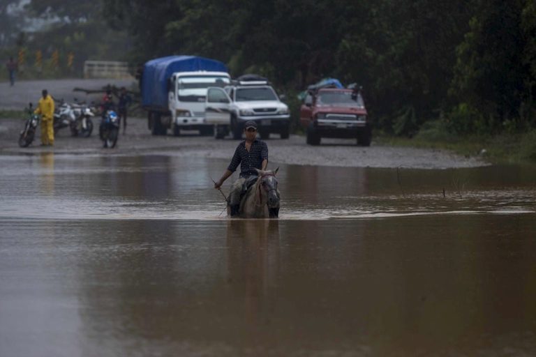
Among the principal damages were fallen trees and electric poles, landslides, roofs torn off, and houses partially or totally destroyed. Two people were buried in the collapse of a primitive mine. Some 30,000 people were evacuated. There was damage to schools and hospitals, plus bridges that collapsed due to the swollen rivers. There was also extensive flooding of properties.
The effects of Eta came from both the storm-force winds and the associated rainfall. In the next few days, these effects may be felt in Jamaica, southeastern Mexico, El Salvador, southern Haiti and the Caiman Islands.
The predicted path of the storm has Eta’s center moving through Honduras until Thursday afternoon. If it then turns northeast, as expected, it will emerge over the Gulf of Mexico sometime tonight.
According to predictions, the storm could strengthen again once it enters the Caribbean waters. The weekend would then see it approaching the Caiman Islands and the west of Cuba as a storm once again.
Eta was predicted to cause precipitation “with the same characteristics” as Hurricane Mitch in 1988.
The passage of Hurricane Eta has revived memories of the devastation caused by Hurricane Mitch in Nicaragua. According to the official data from that 1998 disaster, Mitch left 2,863 people dead in the country. Meteorologist Agustin Moreira spoke with Confidencial in an interview broadcast on the YouTube television news program Esta Semana.
Moreira said that Eta, is similar to Mitch in the quantity of rainfall. This includes the rainfall it has already generated and the precipitation it will continue generating over the next three days. However, up until now, Eta hasn’t caused a large number of deaths.
“It has the same characteristics as what happened with Hurricane Mitch, because it’s bringing us heavy rainfall. The only difference is that Eta has affected a totally different topography,” Moreira stated.
Despite differences in wind speed and area of impact, the meteorologist explained, Hurricanes Eta and Mitch have similar barometric pressures. That is, there’s an extreme accumulation of water. In addition, both moved over the territory at speeds under 12.5 miles an hour.
“Hurricane Mitch measured 902 millibars of barometric pressure, and Hurricane Eta had 934 millibars. However, on the first occasion, the effects were felt in the western zones, where we had the Casita volcano incident. [This was a disastrous mudslide that killed over 1,000 people.] Now we’re seeing the effects in the northern zone, where the topography is totally different. The mountains there are generating the current conditions, such as flooding, landslides and overflowing rivers,” Moreira explained.
Guillermo Gonzalez, director of Sinapred, told the official media that Eta’s characteristics were more similar to Hurricane Joan in 1988. Joan was a Category 4 hurricane, with winds over 145 miles per hour. According to official reports, that phenomenon – which occurred 32 years ago – left 121 dead, 19 missing and over 220,000 affected.
PUBLICIDAD 3M
Confidencial es un diario digital nicaragüense, de formato multimedia, fundado por Carlos F. Chamorro en junio de 1996. Inició como un semanario impreso y hoy es un medio de referencia regional con información, análisis, entrevistas, perfiles, reportajes e investigaciones sobre Nicaragua, informando desde el exilio por la persecución política de la dictadura de Daniel Ortega y Rosario Murillo.
PUBLICIDAD 3D